Two different data file formats are possible. A maximum of 250 coordinates is allowed. The coordinates are dimensionless and in terms of x/chord and y/chord. An extensive file of airfoil coordinates is maintained by Dr. Michael S. Selig of the Applied Aerodynamics Group at the University of Illinois at Urbana-Champaign. Additional information may be found at http://amber.aae.uiuc.edu/~m-selig/ads/coord_database.html This should be considered as the standard for airfoil coordinate files. The default file extension is .dat but .cor is also included.
After the data file has been read it will be shown graphically on the main display and in the tabular grid shown below.
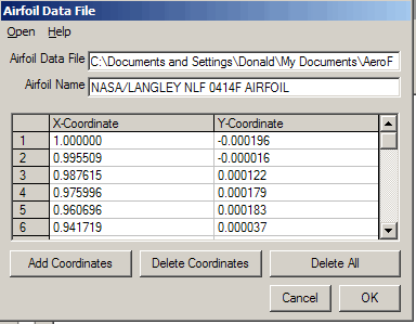
The first line of the data file is always assumed to be the airfoil name. It is shown in the "Airfoil Name" text box and may be changed as desired. The data is displayed in a grid table with limited editing capability. Use the mouse and/or arrow keys to navigate in the table. The selected coordinate pair will be denoted on the airfoil by a red circle. It is NOT possible to create a data file using this table. Creation of airfoil data files is described in the section below.
Coordinate points may be added, modified, or deleted as necessary. Some checks are performed on the data as it is being read and appropriate warning messages are displayed.
The first format requires an airfoil name/description in the first line and is followed by x and y coordinates. Data files that are created from some drafting or design program packages may include z coordinates. If z coordinates are included in the data file, they are ignored. The coordinates begin at the trailing edge of the airfoil, continue along the surface, and terminate at the trailing edge. The coordinates may be either top or bottom surface first. Data input is free format but should not contain any blank lines. Blank lines and non-numeric data (other than the title line) are flagged with a warning message and are not shown in the data table.
The second data file type has a mixed upper and lower surface. This format requires an airfoil name/description in the first line. The second line contains the number of coordinate points that describe the top surface and the bottom surface. The third line is blank. Coordinate data pairs then follow. The top surface is given first, followed by the bottom surface. Data files that are created from some drafting or design program packages may include z coordinates. If z coordinates are included in the data file, they are ignored. The surface coordinates begin at the leading edge and continue to the trailing edge. A blank line separates the top surface coordinates from those of the bottom. Data input is free format. This format is inflexible and unable to tolerate any blank lines or non-numeric data within the coordinate fields.
Airfoil data files which are created manually should be prepared using a text editor which will save the data is a "pure" ASCII format. An example of this type of text editor is Windows Notepad, typically found in the Programs\Accessories directory. Other text editor or spreadsheet programs (such as Word, WordPerfect, WordPad, Excel) may be used but the file MUST be saved in the "text only" form. Data files that contain any text formatting information, such as the Windows .doc or .rtf, or Excel .wk1 will not be readable.
After a set of airfoil coordinates has been read or created from any source, including the create airfoil inverse model, the individual coordinate points may be edited using this grid.